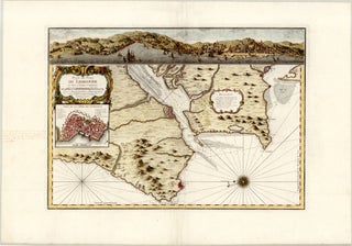
Lisbon, Portugal
Scarce and attractive triple depiction of Lisbon by Bellin
Paris: Dépôt des cartes et plans de la Marine [?], 1756 (dated)
63.4 x 45.1 cm / 25.0 x 17.8 in
Description
This beautiful, large 1756 French copper print illustrates Lisbon on one sheet in three different ways – on a chart, through a panoramic view, and as a city.....
Edinburgh, Scotland
Very rare chart of the Firth of Forth by Bellin
Paris: Dépôt des cartes et plans de la Marine [?], 1764
26.7 x 19.1 cm / 10.5 x 7.5 in
Description
This detailed chart of the Firth of Forth, here referred to as the Gulf of Edinburgh (Golphe d'Edinburg), is from Jacques-Nicolas Bellin’s Le Petit Atlas Maritime. With close to.....
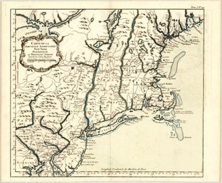
Northeastern United States
Scarce, larger version of Bellin’s map of New England and the Northeast of the U.S.
Paris: Dépôt des cartes et plans de la Marine [?], 1764
37.6 x 32.5 cm / 14.8 x 12.8 in
Description
This elegant map is from Jacques-Nicolas Bellin’s Le Petit Atlas Maritime. With close to 600 charts and a strong focus on harbour cities and towns, this atlas is considered.....
London, England
Very rare plan of London by Bellin
Paris: Dépôt des cartes et plans de la Marine [?], 1764
17.4 x 22.8 cm / 6.9 x 9.0 in
Description
This detailed London city plan is from Jacques-Nicolas Bellin’s Le Petit Atlas Maritime. With close to 600 charts and a strong focus on harbour cities and towns, this atlas.....
New York City, New York
The earliest obtainable plan of New York City
Paris: Dépôt des cartes et plans de la Marine [?], 1764
16.4 x 21.2 cm / 6.5 x 8.3 in
Description
This fascinating chart depicting colonial New York City is from Jacques-Nicolas Bellin’s Le Petit Atlas Maritime. With close to 600 charts and a strong focus on harbour cities and.....