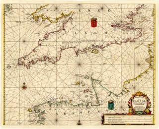
Hendrick DONCKER

1626 - 1699

Hendrick Doncker was born in 1626 and died in 1699, spending his life and career working in Amsterdam, Netherlands. Not much is known about his family background and education. He established himself as an independent professional by joining the Amsterdam booksellers’ guild in 1647. Doncker initiated a multi-generational family line of maritime publishers, actively manufacturing and selling navigation instruments alongside printed material. His business was later continued by his son, Hendrick Doncker II, who maintained the family workshop and published expanded editions of his father’s foundational maritime atlases until the early 18th century, before the shop’s printing stock was eventually acquired by the prominent publisher Johannes van Keulen.

Doncker played a significant role in the development of 17th-century Dutch maritime cartography by prioritising geographical accuracy and frequent corrections over purely decorative reuse of outdated printing plates. Operating during an era when contemporary commercial mapmakers routinely copied older materials, Doncker differentiated his work by continually refining his copperplates with the latest navigational data provided by returning mariners. For several years beginning in 1655, he collaborated with contemporary publishers Pieter Goos and Anthonie Jacobsz on the pilot guide De Zeespiegel. Doncker subsequently produced independent publications and developed entirely original charts, heavily reducing the delay between new geographic discoveries and public disclosure. His major cartographic contributions include his debut maritime atlas, the Zee-Atlas ofte Water-waereldt (1659), which expanded significantly in scope over its 50-year print life, alongside procedural pilot guides such as the Lichtende Columne ofte Zeespiegel (1655) and the Nieuwe Groote Vermeerderde Zeeatlas.

Hendrick Doncker is remembered as an exceptionally precise and conscientious maritime publisher whose commitment to regular factual revisions set a higher standard of functionality for navigation charts during the Golden Age of Dutch cartography.