Georg BRAUN
1541 - 1622
Georg Braun was born in Cologne on January 1, 1541, and died there on March 10, 1622. Not much is known about his family background and early education. His primary life path was that of a Catholic cleric, serving for decades as a canon and dean at the church of St. Maria ad Gradus in Cologne. Studying at the University of Cologne, Braun received a Baccalaureus (Bachelor) degree in 1561 and graduated with a Magister Artium (Master of Arts) in 1562. Following his graduation, he briefly entered the Jesuit Order as a novice before dedicating himself to theology and his ecclesiastical duties, which eventually intersected with his intellectual pursuits in topography and geography.
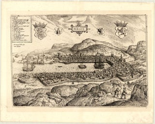
Braun holds a position of outstanding importance in the history of cartography as the principal editor, coordinator, and text author of the monumental Civitates Orbis Terrarum (Atlas of Cities of the World), a milestone in publishing history. Published in six volumes between 1572 and 1618, it introduced a unique blend of geographical accuracy and high artistry and is universally recognised as the first systematic, comprehensive city atlas in cartographic history, specifically designed as an urban counterpart to Abraham Ortelius’ 1570 world atlas, Theatrum Orbis Terrarum. For his work, Braun leveraged a vast network of well-travelled contacts to acquire firsthand drawings, topographic surveys, existing plans and maps, and other source material. He managed the production entirely, writing the detailed historical, geographical, and economic commentary for 546 city plans, prospects, and bird’s-eye views. The project was implemented in partnership with the prominent Flemish engraver Franz Hogenberg, who executed the copper plates for the first four volumes. Following Hogenberg’s death in 1590, Braun continued the enterprise alongside Hogenberg’s son, Abraham, and the artist Simon van den Neuwel. Braun’s approach set a structural precedent for urban geography by framing maps with landscape topography and detailed figures in traditional local attire, adding vital cultural context to the scientific layouts. Outliving all his original collaborators, he was the sole member of the founding team to witness the publication’s completion.
Georg Braun will be remembered as the chief editor and driving force behind the first modern city atlas, revolutionising – together with Franz Hogenberg – the history of cartography by transforming 16th-century urban topographies into a vibrant, comprehensive, and definitive visual and textual record of world civilisation during the late Renaissance.